Foundation design in St. Paul demands rigorous subsurface data. The Standard Penetration Test per ASTM D1586 remains the primary tool for characterizing the complex glacial stratigraphy underlying the city, from the thick deposits of the Des Moines lobe to the interbedded alluvial silts of the Mississippi River valley. We execute split-spoon sampling with calibrated automatic trip hammers, recording N-values every 5 feet through overburden that can exceed 120 feet in the downtown district. Encounters with boulder-rich till near the Highland Park terminal moraine require careful refusal logging and coordination with our drilling crew to switch to coring. St. Paul's building officials review these blow count logs against IBC Chapter 18 to verify bearing capacity assumptions before issuing permits. The data we generate feeds directly into seismic site class determinations under ASCE 7, where soft clay pockets in the Phalen Creek paleochannel can drop a site from Class C to Class E. Our laboratory in the Twin Cities processes all disturbed samples from the split spoon for index testing within 48 hours of field recovery, preserving natural moisture content for accurate grain size distribution correlations.
Hammer energy calibration per ASTM D4633 is non-negotiable — uncorrected N-values can overestimate bearing capacity by 30% in St. Paul's clay till.
Service characteristics in St. Paul
Risks and considerations in St. Paul
The Twin Cities' freeze-thaw cycles penetrate 42 inches deep on average, a depth that wreaks havoc on poorly characterized near-surface soils. SPT refusal in St. Paul often masks a thin boulder within a dense till matrix rather than true bedrock: misinterpreting this contact can shift foundation type from spread footings to deep piles unnecessarily. We log each refusal event with driller notes on rig chatter, advancement rate, and sound to distinguish cobble refusal from sandstone contact. The St. Peter Sandstone, when encountered at depths of 80 to 140 feet in downtown borings, can produce artesian conditions that collapse the borehole walls between spoon retrievals. Our crews carry weighted mud and set temporary casing as standard protocol for these pressure zones. The Mississippi River bluff line along Shepard Road introduces another variable: colluvial reworking of the Decorah Shale creates slickensided clay seams with residual friction angles below 12 degrees, a condition that SPT samples alone cannot quantify without supplementary laboratory shear testing on undisturbed specimens.
Our services
SPT execution in St. Paul requires integration with complementary field and laboratory methods. Our scope typically includes the following deliverables:
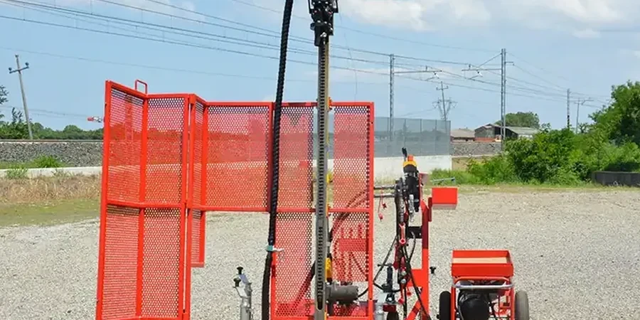
SPT Drilling with Mobile B-53 Rig
Track-mounted rig access for tight St. Paul residential lots. Continuous sampling with automatic hammer, mud rotary through caving zones.
Laboratory Index Testing
Moisture content, Atterberg limits, and sieve analysis on split-spoon samples. Turnaround within 48 hours for active construction schedules.
N-Value Correction & Liquefaction Screening
Seed & Idriss cyclic stress ratio analysis for Mississippi River floodplain sites. Corrected N1(60) profiles with fines content adjustment.
Bearing Capacity & Settlement Report
Allowable bearing pressure per Terzaghi-Peck method with SPT correlations. Immediate settlement estimates on sand lenses within the till.
Common questions
What is the typical cost of an SPT investigation in St. Paul?
For a standard residential or light commercial site in St. Paul, SPT drilling with two borings to 30 feet typically ranges from US$470 to US$810 per boring, including mobilization within the Twin Cities metro, field logging, and N-value reporting. Deeper borings, multiple shifts, or difficult access along the river bluffs increase cost.
How deep do you drill SPT borings in St. Paul?
Depth depends on the structure. Single-family homes in the Summit Hill area often require 25 to 35 feet to pass through the Decorah Shale residuum. Commercial buildings downtown with basement levels can require borings to 120 feet to characterize the St. Peter Sandstone and underlying Prairie du Chien dolomite.
How do you handle cobble and boulder refusal?
Refusal is logged as 50 blows over 6 inches with a note on the boring log. We then advance casing or switch to NQ coring to identify the obstruction. In St. Paul's till, refusal is often a granitic boulder from the Canadian Shield transported by the Des Moines lobe, not bedrock.
What seismic site class does SPT data determine?
N-values averaged over the upper 100 feet define the site class per ASCE 7 Chapter 20. St. Paul sites on dense till typically classify as C or D. Sites along the river with thick soft clay can drop to Class E, requiring a site-specific response spectrum.
Do you provide corrected N-values or just raw field values?
We deliver both. The field log shows raw blow counts. The final geotechnical report includes N(60) values corrected for hammer energy, rod length, borehole diameter, and overburden pressure, ready for direct use in foundation design equations.